Rod
R. "The remains of the scotch
settlement house are located in the Pleasant Lake Wild Forest area off the
Scotch Settlement Road. It is a ways back off the trail. The work that must have
gone into it is amazing. In the immediate area are also signs of the old
farmstead including a small orchard and several small fields." 06/25/2008 Rod R. follows-up with; "I've done some additional research on it and
found that it may have once belonged to the family of a James Lockie who came
from Scotland between 1819 and 1830." On 5/1/13 Jan
writes "I just loved seeing these old photos.. I am a descendant of a James
Lockie born 1813 in Parish of Maxton, County of Roxburgh, North Britain, living
in Rossie, NYS 1850 with wife Elizabeth Faichney. Not sure if they are one in
the same, nd I am not aware of when James Lockie arrived in the area. I do have
more information on other Lockie family members. Amazing to think they may have
resided in this house!"
From comac1103 (via
Flickr.com):
"Another excellent view; you have some superb shots on the site
my friend."
Taken on
04/15/08 Another side-view, slightly different angle. The remains
of something metal was sitting here (seen at the bottom of the picture beside my
backpack). Maybe a burning barrel, or something newer?
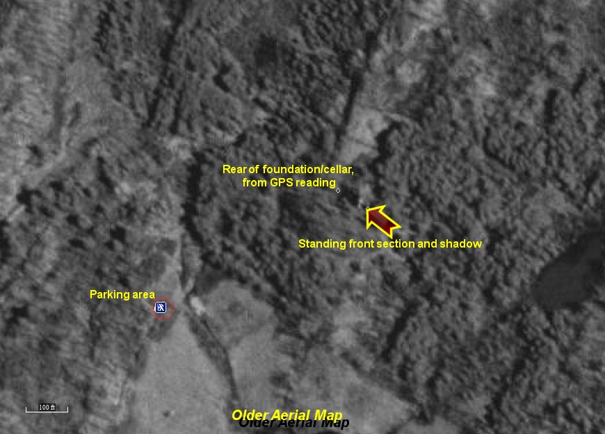
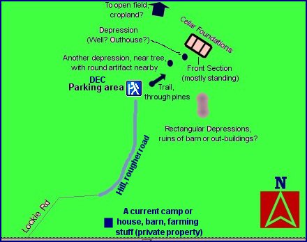
Site map The
website visitor 'Briarscratch' originally submitted a very excellent photo
of what he called the "Scotch Settlement House". He said it was
built sometime between 1830 and 1860. Also see 'Burned out stone house
on Scotch Settlement Road, St. Lawrence County' on the
previous page. I
had always wanted to get out and take more photos of this house and a few
years later, via this website, another visitor - Rod R. - sent me info and a
map on how to find this building. The map for directions as well as
the site map are above. I
set out to find this house and any surrounding ruins one day in mid-April
2008, once the weather got nicer. After updating the maps in my GPS
and selecting the location to find via the GPS (according to Rod's map) I
had little trouble finding the Pleasant Lake Wildlife Area's parking lot on the
small and kinda rough dirt road called the
Lockie Road, off from the Scotch Settlement Road near the Rossie/Oxbow
area. I had to park the car a distance away from the parking area as I
didn't think my car would make it the last little distance because of the
rough road. Once
at the parking area the DEC land sign was visible and little else. The
trail lead into the pines, just as Rod R. describes in his map. A
short trip over a short swampy area (the remains of some sort of metal piece
of equipment is sitting in the swamp, farm-related?). In the pines the
trail itself is overgrown and hard to even find after a bit. But I
headed in the likely direction that the trail seemed to be heading toward
but it was quickly gone. Fortunately a quick look around was all I
needed. There
it was, a short distance away - the ruins were easily seen. An
incredible and beautiful ruined gem. I
did a quick walk-around as well as went inside (if you can call it "inside",
there's little left in the way of walls). I also walked around it a
bit and found what seem to be the extremely old ruins of other buildings,
hard to even believe that they are ruins and not just natural formations
(see above). One is larger, a barn perhaps. Another seemed to be
not very wide but quite long. This one had just remains of wood and a
depression. Nearby are also the remains of some clearings (on the edge of
a small cliff and near a stream), some depressions that were probably wells
and outhouses, etc. Beside one depression, a little further from the
house is a small hand-wheel sort of thing (see photo above). Beside
the house sits a large piece of metal (see photo above, sitting beside my
backpack); a burning barrel, or maybe something that was brought in more
recently by partiers or hunters? What
remains of the building itself is mostly white sparkly granite interspaced
with what also looks like a softer stone, sandstone maybe, mixed in.
The majority of the building has collapsed inward, with what was probably
the front still mostly standing, and part of the sides. Very little of
the back is standing and there seem to be three cellar sections. The
front cellar section has a large, very old tree growing out of it - showing
just how old these ruins are and how long they have probably been abandoned. Likely
the front and rear sections of cellar had wooden structures over them, the
middle being the stone. Above the doorways are some remaining pieces
of wood, which all look charred. Possibly the building had burned? There
are no remains of any roads near it, except for the Lockie Road quite a
distance out. After
taking many, many photos; marking the location with my GPS; and also taking
a lot of video (which will be added soon) I reluctantly headed back to the
car - wondering about the story behind this house and the people who built
and lived there. 'Briarscratch'
has contacted me again with lots of information that he has researched on
this great old house. Below is an article from the Wednesday April 20, 1927 edition of the
Gouverneur
Free Press about the fire that destroyed this house many years ago (thanks to
'Briarscratch' for finding this on the site
https://news.nnyln.net):
300 Acres
of Lockie Farm Swept By Fire
Buildings are Destroyed by Stubborn Blaze Which Last Days - Small Army of Men
Finally Subdue Flames
An Army of farmers and farm hands last Wednesday afternoon gained the upper hand
and finally conquered a forest and grass fire which had been raging for a week
on the William Lockie farm, town of Rossie, about a mile from Pleasant Lake, and
which in the sweep consumed a large cow barn and farm house on the premises.
Upwards of 300 acres of land on the farm were burned over.
The farm buildings were unoccupied except that the barn, one of the largest in
that section, housed valuable farming machinery, tools and about ten tons of
hay. The farm had not been operated since the death of Mr. Lockie about four
years ago, since which time Mrs. Lockie had made her home with her
brother-in-law, James Lockie, in Rossie village.
The fire smoldered for several days before sufficient wind came to spread it.
Once it had started, it spread with great rapidity and neighbors found after
battling the flames for one or two days that they were unable to cope with it.
The fire reached patch after patch of woodland where light timber stood and it
swept the trees before it. It continued on its way and finally reached the hilly
portion of the farm when it became noticeable to others in the section. A
summons was sent to Fire Warden Walter Johnson. He inspected the situation and
finally corralled a force of 15 or 20 men to fight it. For a time on Monday it
appeared that they had gotten the upper hand on it, but Monday night a steady
wind fanned it to the extent that it again reached great proportions and spread
with great speed.
On Tuesday the fire swerved its direction towards the farm buildings and at
12:30 in the afternoon both buildings were afire. An effort was made to remove
the tools and machinery in the barn but the fire raged so fiercely that men
could not bear the heat and finally gave up their task. They then turned to
protecting other buildings in the vicinity and succeeded. The Farm house and
barn on the Mary Lockie farm were threatened, but the desperate work of the
small army of firemen prevented their destruction.
Neighbors in the vicinity of the Lockie farm are inclined to be far apart in
their estimates of the area burned over. Some place the acreage swept by fire at
100, while others say a tract of at least 865 acres was burned over.
The fire fighters fought bitterly throughout the night Tuesday and all day
Wednesday until about 4 p.m. when the last spark of the fire was extinguished.
They fought with brush, shovels, rakes, picks and every conceivable weapon in an
effort to subdue the blaze. Ditches and long trenches were thrown up in heir
battle but when the fire reached them it leaped them without difficulty and
continued on its way.
On Tuesday forenoon persons who watched it declare that between 9 a.m. and 12
noon it swept over more than four miles in one direction. It was at that time
that the buildings on the Lockie property were consumed.
The Lockie farm at one time was regarded as one of of the best in the vicinity.
In late years, however, it has fallen into disuse and available lands had not
been pastured, and this condition aided the fire in its spread. The farm
contains 506 acres and it is estimated by some that nearly four-fifths was swept
by the fire.
The farm is situated near the Scotch Settlement Road of the town of Rossie, two
and a half miles east of the village of Rossie.
No estimate of the value of the property or the monetary loss to the owner could
be obtained.


 © Copyright 2004-
OABONNY. All Rights Reserved. Site first online on July
28, 2004
© Copyright 2004-
OABONNY. All Rights Reserved. Site first online on July
28, 2004 


