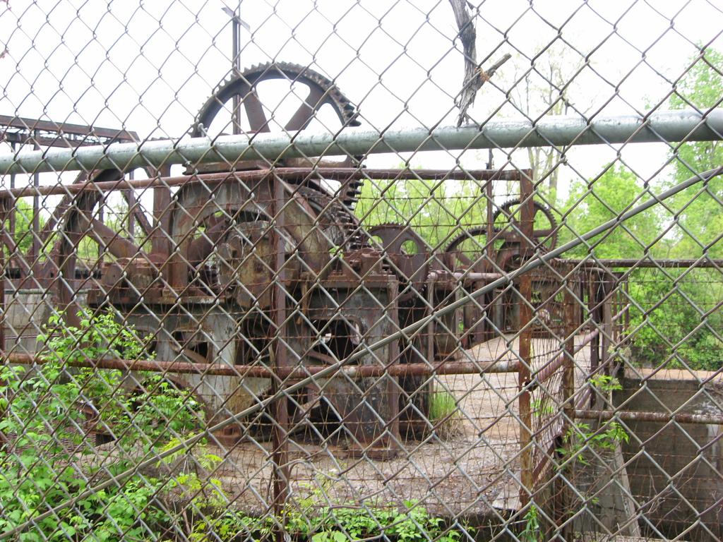
OABONNY.COM
PAGE 21 - All Rights Reserved. Copyright © 2004-2021 OABONNY / Click thumbnails for full-size pics, BACK to return to this page.
Previous Page Click for the OABONNY.COM Facebook Page Next Page
Behind the Calcium Post Office, unknown what the building was
Taken on 05/14/08
Part of the Ryor's Turkey Farm, on a small dead-end road behind the Calcium Post Office, Town of Leray

There is also a connected wooden rear section, larger then the part shown here but obscured by trees - I couldn't get a good shot of it.  Another large unconnected barn or building has previously been demolished.  Now owned by Millsite Family Adventures, Inc. of Carthage.  For more info on Calcium itself see the JeffCoWiki entry here.
*Suggested by Kathy, who wanted to know what this building was (and so did I).
Submit a Comment

Comments from visitors:
Thanks to the members of the JeffCoWebboard.com (WWR, Ringoffire436, tree68, OddJob, inspector71, dirtyhands, magnum, BryGuy) for the help on finding a little about what this was.  'Dirtyhands' writes that from the architecture it looks to be 1920's.
Chris writes "Hi there - loved the picture! I used to live in the house directly across from the turkey farm (1985-1988). My parents bought our house from the Ryors when we first got stationed at Fort Drum. The bldg you are looking at was the view I had out my bedroom window. It was in a little better shape back then, but just slightly. At the time, there was a couple and their baby that lived in the upstairs floor of this bldg, which I remember to be the offices of the turkey farm itself (I think they were related to the Ryors somehow) - there used to be several large turkey barns out back with wide gradual sloping roofs that were fun to jump off of when the snow was deep. I learned to parallel park in that parking lot right there :) Thanks for the memories!"
Eric Y., who lives nearby, has done some research on Calcium and this building.  He writes "The town was originally called 'Sanford Corners.'  In 1900 the entire property was a gladiola farm (everything that is now considered Calcium was this gladiola farm).  The building in your picture was a packaging plant for the gladiolas.  Next to that building there's a train depot that was used to ship the gladiolas via train.  In the building the gladiolas were cut to size and packed in calcium chlorate.  The owner of the gladiola farm was also the proprietor of Sanford Corners and he had developed the packaging method for the gladiolas involving calcium chlorate so in a way of being creative he renamed the town 'Calcium'.  His name was Stanley Bishop and he was married to Miriam Bishop, both of which built the house that I live in now in 1910 (my house is directly in front of the abandoned building)."
James S. P. writes "The information concerning the old Ryor Turkey Farm and the comments that it was a packaging plant for the cut gladiolas is totally wrong! I live in the old Ryor home at 24675 Cty RT 138 which was built in 1912 by Madison Cooper who in fact built the Ryor Turkey Farm building which was a Cold Storage and Refrigeration Company (they built cold storage vaults for other businesses worldwide) he held patents in cold storage refrigeration using calcium chlorate a dry storage process in the United States, France, Germany, Great Britain and Austria. Madison Cooper not Stanley Bishop owned and operated this business. It was Madison Cooper who named the town Calcium in 1911 because of the issue with Stanfordville in St. Lawrence County vs. Stanford Corners Road town of LeRay, Jefferson County and his mail always getting sent to the wrong place. He picked the name because of the calcium chlorate piles next to his business. Now in the early 1930s when electric took over cold storage he started a gladiolas bulb mail order business out of this building the building was idea because it had storage vaults in it so he could now store the bulbs in ready for mail orders. Around the building and up and down Stanford road he grew 25 acres of gladiolas, iris and peonies. There is no truth that Stanley Bishop developed a packaging method for the gladiolas involving calcium chlorate. Mr. Cooper simply sold my mail order gladiolas bulbs. Upon Mr. Cooper his death in 1946 the building was purchase Mr. Michael Ryor who used the building which had the storage vaults in it to slaughter turkeys and cold store them. This business closed in 1978. Of note Mr. Cooper constructed a large wooden baseball stadium for his sponsored baseball team in the 1920s and 30s. Mr. Cooper was the prime mover in the formation of the Amateur Sports Federation, Sate-wide ! organiza tion, in 1931 in became its president at its inception. He was also the editor of the federation's official magazine, "Amateur Sports". This stadium was torn down in early 1940s for a rail track which runs on to Ft Drum. He also was the publisher of the "Modern Gladiolus Grower" later called "The Flower Grower" magazine for 29 years. The house I live in was designed and build by Mr. Cooper in 1912 it is a beautiful preserved Arts and Crafts style home. It is said that when he build this home that electricity came to Calcium as this house was electric. The house was even insulated when it was build. Its walls are filled with cedar wood shavings. This is how ice boxes were insulated to keep foods cold so he designed his house in the same way to keep heat in."
On 9/14/11 Sue G writes "Ryor Turkey Farm was owned by my uncle, who also owned Madison Cooper's house - his name was Russell "Tom" Ryor (not Michael Ryor). Russell Ryor was married to my aunt Rhea Cooper. My decendants are the William "French" Cooper family. I live across the road from the Madison Cooper home and am the fifth generation to live here in this house. Madison Cooper originally used the plant for the cold storage business and my uncle used it for his turkey business."
On4/27/14 Lyndsay Ryor writes "I used to live in that building, which we called 'The Plant'. Eggs were candled and hatched there, Turkeys were processed and housed in the back as well. I remember it always smelled like comet in there. I remember Dad's Toms were in the back part of that building. When we sold the yellow house, we moved into the upper floors of the plant, which we converted into an apartment. This would have been mid eighties. Regarding the history of the place, there was a great article a couple years back: Watertown Daily Times Article it appears to be accurate if you want the true history of the place."
Donnatburg Bridge, Redfield
Taken on 05/14/08
Donnattburg Bridge, over the Independence River in Lewis County, Otter Creek/Glenfield area, Donnattburg Road.  Built in 1902 and long-closed.

The small building in the right edge of the picture is a Hudson River Regulating District gauging station.
Suggested by Meagan M.
Submit a Comment


Comments from visitors:
Thanks to Will H. for the correction on the area.

Donnatburg Bridge, Redfield
Taken on 05/14/08
Looking straight onto the bridge.
You can still walk over the bridge, at your own peril...
Submit a Comment


Comments from visitors:
From Dawn in Atlanta Ga: "I grew up on Donnattburg road from age 8-18. Memories flooded me when I saw your pic of the bridge. It used to be functional when I lived on the road there.. in fact that whole road was a dirt road for years.. then they paved it to the bridge. When I went to college in 83..they closed the bridge and the pass to Austin Road... eliminated a great short cut!
I used to sit on that bridge and read and throw rocks into the river."
On 1/24/12 Kathy Baxter writes "Good thoughts of walking on that bridge - As a young girl many years ago we would go to the Independence River after haying on our farm in Glenfield. Dad would take us and all our friends on the back of the truck to swim. What a wonderful time we all had. I took our kids there also. Now there is a new lovely house there at the old swimming hole."
On 4/8/21 Rob writes " I remember this bridge!! I remember my babysitters farm just up the road and i stayed a couple months there one summer, god i couldn't have been more than 9 or 10 years old. We would walk down to this bridge and swim in the creek there and there was always crayfish to find. What a great picture and flashback!"
Donnatburg Bridge, Redfield
Taken on 05/14/08
The 1902 plaque

Submit a Comment
Maple Hill Cemetery Crypt
Taken on 05/14/08
Old abandoned crypt (or vault) at the Maple Hill Cemetery on County Route 160 (Middle Road), Rutland Area near Watertown.
This is where they kept the bodies during the winter months when the ground was too frozen to bury them.  This kept the bodies cool yet not frozen.
Submit a Comment

Comments from visitors:
From comac1103 (via Flickr.com): "Marc this is a cool shot; that board keeping the door closed is weird are they trying to keep someone or something in."
From Leo Alen (via Flickr.com): "that door is so inviting"
Maple Hill Cemetery Crypt
Taken on 05/14/08
Another view

Submit a Comment
Maple Hill Cemetery Crypt, closer view
Taken on 05/14/08
Closer shot.

Submit a Comment
Maple Hill Cemetery Crypt, inside
Taken on 05/14/08
Inside the small crypt.
Yea, kinda creepy.  This looks like it has not been used for many, many years.  Some junk is piled inside the crypt, but the cemetery itself is well-maintained and still used.
The walls of the crypt were covered with some sort of masonry work, and chipping off in some places but still in fairly good condition.  The floor may have once been bricked, now they are piled and jumbled all over.
Submit a Comment

Comments from visitors:
From chocolatepoint (via Flickr.com): "Very cool photo. I've never seen inside a crypt, so tanks for sharing! Nice webpage too with all the abandoned sites up your way."
Water Street Train Trestle, Watertown
Taken on 05/21/08
The old train trestle off from Water Street, over to Sewalls Island, Watertown

Bridge and location suggested by AJR II.
Submit a Comment
Remains of old Chaumont bridge
Taken on 06/10/08
Remains of a railroad bridge in Chaumont.

Suggested by Don D.

Remains of old Chaumont bridge
Aerial photo taken by the webmaster, showing remains of the old bridge as well as the newer highway bridge.
Submit a Comment


Comments from visitors:
Jill writes - "You are correct, the railroad used to run across that portion of the Chaumont River. The tracks continue into Limerick, and Brownville. The DANC waterline actually follows the old railroad tracks."
On 2/6/12 Bill Boyer writes "The two bridges were removed in the fifties. The highway bridge was a mechanically operated draw-bridge that hadn't operated in many, many years. It was on the north end of the crossing and had huge, overhead concrete counter-balance weights that you actually drove under, that lightened the load-lift of the section of highway when ships went through. The waterway was a fairly busy run of freight in past years, so the older people said. It had huge iron cog-gears that operated the section. There was a article in the Watertown Times about when they removed the railroad spans, they blew the sections with explosives and when the pieces were removed from the river, a 1946 Crosley auto was found that had been stolen in Watertown with nearly no miles registered, and was disposed of by the thieves off the tracks into the river. [case closed for they thought it would never be found]"
Remains of old Chaumont bridge
Taken on 06/10/08
Close-up of the bank shown in the left of the previous picture.

Submit a Comment

Comments from visitors:
Lloyd writes "The large pier on the left in this picture once supported a swing span. The bridge was abandoned by the New York Central railroad in the early 1950's and removed about 15 years later."