Nicole R.
writes: "I grew up in Great Bend and most of my
family did too. My sister posted a comment about the church as well. I remember
just staring at the church wondering what mysteries it held and what secret
meetings took place there as a kid. I still have a fascination with the church
and as run down as it is it is still very beautiful."
Dianna B writes: "I grew up in great bend new york, now living in New Jersey for the past 17 years, its nice to see pictures
of my home town. I remember when I was about 5 or 6, walking hand in hand with
my grandmother, Blanche Rambone down the hill to attend this church on Palm
Sunday, I remember my little dress and my white gloves that she made sure I
wore. I also remember her receiving the palm and I carried it home. As I grew
older and played with my friends on that very street, I always watched the
church and wondered why no one ever used it again. As an adult it always brings
back memories of a very special person in my life that passed away many years
ago. I've always loved this little church, and wondered why it was in such
disrepair over the years."
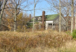
Taken
on 11/05/08 Ruins of the inn at Mexico Point State
Park This was once a stablehouse and then converted into an inn, which
later
burned. The Mexico Point State Park is on the grounds of the inn, with an
information kiosk showing some old photos and info about the inn. There
are still some of the related buildings standing nearby, which seem to be used. For
more info about Mexico Point State Park and trails
click here.
Linda M. writes
"Definitely a Gem on the shores of Lake Ontario. This was our family's summer
home until 1986 when State of NY purchased it. Loaded with history -
the original structure dated back to the late 1890s or possibly 1860s. Still
remnants of the huge fireplaces that graced the large banquet halls and entrance
pillars remain. A Revolutionary War spy named Silas Towne is buried
there and his monument was erected in 1871. Look for Spy Island on the trail. Occasional
tours are conducted thru the replica of an 11th century manor house built in
approx. 1930 and created by artists from Columbia University. Unique carvings
and artwork still remain." On 9/18/12 Michele
Marano writes "My
dad and uncle were the owners of Mexico Point. We were the ones that provided
Professor Casey a lifetime lease of the property. I wrote an article about the
property and it was published in the Independent Mirror.
https://realestatelovematch.com/2010/11/18/a-nostalgic-reading-mexico-point-new-york/
For the complete article go to
https://realestatelovematch.com/2011/06/13/the-mexico-point-story-by-michele-marano/
It gives much more of an actual insight to the property in its true form
than any other person's "take" on what they heard about it."
Paul writes: "This is a great shot my friend keep up the great
work."
Taken
on 11/18/08
Martin H. wrote with info and
directions to the old Robbins farm ruins on Massey Street Road; "I would like to
see a picture of the old cow barn on my Grandfathers farm. It is located on the
right side of Massey st just before you cross over Rte81. The house and upper
barn are still standing. According to what I see on Google earth the old barn is
down." Unfortunately because of the brush I wasn't able to get
very good photos. See below, left for better ones.
Martin H writes: "Was back to
Watertown this summer and went back to my old home place. Brought back many
memories of my days here."
The
following photos taken during Summer of 2009 by Martin H.
Old Robbins Farm ruins on Massey Street Road (also see previous photo).
Taken
on 10/10/07 I just dug these photos out from last
year. Great old deteriorated ruins of what must have been a bridge over
Totman Gulf, Adams/Lorraine area. These ruins seem to be the two vertical structures that
held the bridge up (the photo above is one of them, see the other below). I assume the bridge itself was
mostly wooden. This end
had a stone and dirt ramp leading up to it. This ramp in turn came off the side
of the steep trail leading from the top of this
deep gorge, at a steep angle. This trail is mostly washed out now, but the ramp to the bridge is
still standing and in fair shape (see next row of photos).
When I was younger I went down this steep trail with a friend of mine in his four-wheel drive truck. It was certainly a bit scary even then. Now this trail is
even hard to walk down, and is impassable to vehicles, but it's worth the walk
down the the bottom if you get the chance. See pic below for a
shot of the high cliffs. Addendum July 2016 - Jefferson County has added a
gravel trail along the top of the rim; see the
Totman Gulf
Trail page here. The gulf
or gorge, was named after Calvin Totman, an early settler to the area.
Jack S. writes: "Probably 25
years ago I drove down in the gulf with my old suburban. Wife was sure we would
not get out, but we did. When I was there we drove down the creek bed a half
mile till my wife got scared. We found a road that took you into the gulf where
it had leveled off and drove up the gulf a ways at that time a four wheel drive
could made it to the bridge site. As was said if you can walk down it is a sight
to see. Even if you can't walk the drive on the road has some turn outs where
you can look down into the gulf."
Taken
on 10/10/07 Here's a closer shot of the previous pic,
looking up at it. You can get to these ruins
by going down the Lemay Road until you hit the sharp right-hand turn of the dirt
part of the road, park there and look down to find the trail/road down to the
bottom. The Lemay Road is off from Route 11 outside of Adams, NY and a
distance from Lorraine.


 © Copyright 2004-
OABONNY. All Rights Reserved. Site first online on July
28, 2004
© Copyright 2004-
OABONNY. All Rights Reserved. Site first online on July
28, 2004 


