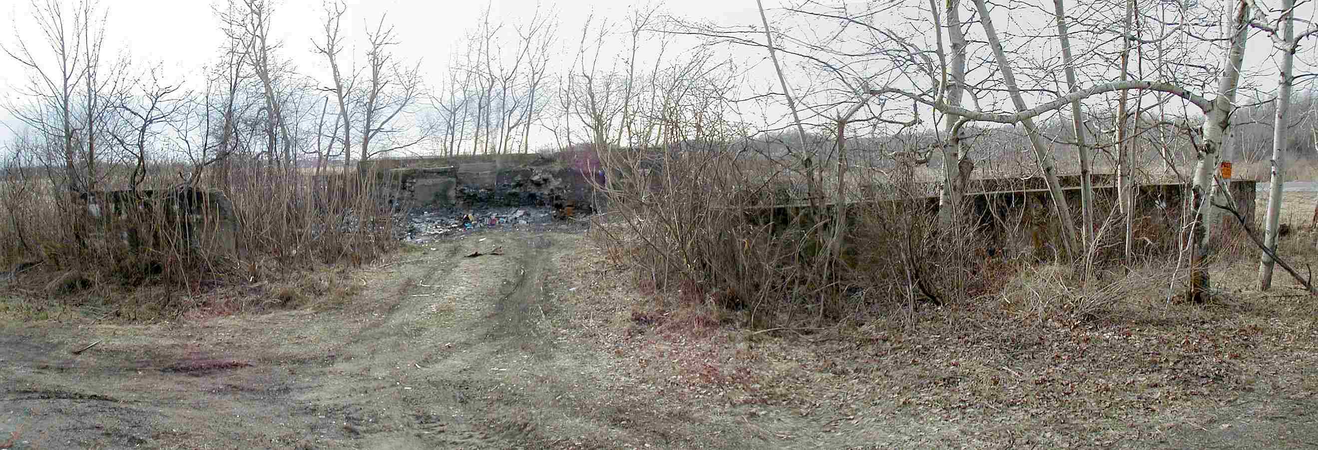
Taken on
06/16/06, photo courtesy of Mike C.
Old Limerick grist mill
foundations


Mike C. writes "This picture is of
the foundation of the old grist mill that sits on the west bank of the Perch
River about one hundred yards north of the State Route 180 bridge in Limerick,
right next to the Limerick Falls. I believe the mill stopped operating
sometime in the mid-1800's." |

Date taken -
unknown, Photo courtesy of Lida Rose.
Rutland Hollow Road, right side of road, as you head out of Watertown.
See Lida Rose's other excellent photos on Flickr,
click here.
 |

Taken on 08/09/06,
photo courtesy of Lida Rose.
Abandoned house by
the Ashcraft Pond, Bear Town Road


Lida P.
writes: this house "is on the Bear Town Road, town of Croghan, next to Ashcraft
Pond. The town of Croghan historian, Jack Sweeney, told me it used to belong to
a man who raised bullfrogs in the pond, for sale to restaurants that served
frogs legs. The snakes moved into the house and it was abandoned. Interesting
bit of rather scary history!"
More photos of this house and the interior on this
page. |

Taken on 08/09/06,
photo courtesy of Lida Rose. Black & white shot of
previous
More photos of this house and the interior on this
page.
 |

Taken in 2004,
photo courtesy of Lida Rose.
Old school house on the
Third Road near Beaver Falls

 *Jack W.
writes: "The school on the third road belongs to John Honer, my neighbor, he is
father Foster Honer bought it when Beaver River was centralized. Fosters
intentions were to retire from faming and raise heifers. Pasturing them in the
summer on the Black River flats where he had a camp and could live and fish and
watch his livestock. The School house was to be his winter home. Unfortunately
fate had other plans. He died a young man." |

Taken on
08/03/06, Photo courtesy of Lida Rose.
Third Bridge near
Deer River
On what
was the Old State Road, off the Deer River-Copenhagen Road. The road is only
maintained seasonally.
 |

Taken on
08/03/06, Photo courtesy of Lida Rose.
Close-up of top of
bridge - 1891 See Lida Rose's other excellent
photos on Flickr,
click here.
 |

Taken on 10/10/08
Strange-looking stone/wood house
and silo, Route 37 near Hammond


Beautiful visitor-submitted photo of this house, taken by Aaron Hall
(link
to his Facebook album) |

Taken on 10/10/08

Front view

 *Doreen comments: "Creepy I think not-but
rather a beautiful aura. I have loved this house since I first saw it
as a child when my family and I travelled thru the town this building
is located at. It has been empty for as long as I can remember. Any
info about its history would be greatly appreciated."
*Nathan M.
writes: "This house is so old it was abandoned a long time ago. My
dad grew up (near) there and it was like this since he can
remember. He tried buying it from the farmer who owns it but he
would not sell this. Its a shame I would have lived there. Now its
a ghost of Hammond's past. I still love to check it out as I go
by. Its a shame the owner won't sell it for refurbishing." |

Taken on 10/10/08
Another angle
 |

Taken on 10/10/08
Stone schoolhouse? Route 37,
near Hammond
 |

Taken on
01/05/07
Flat Rock Schoolhouse. Route 37,
near Brier Hill Update 10/10/08. This little building continues to
deteriorate and part of it has fallen. See pics below:


 *Caryn M. has a bit about this on her websites at
this
link and
this link. |

Taken on 01/11/07
Ruins of old milk factory, along what is
left of the train tracks (which is now a walking/ATV trail) on Elm Ridge Road
outside of Theresa
|

Taken on 01/11/07
Small partial panoramic of a different
view of the previous
 |

Taken on 03/28/07,
photo courtesy of Scannerman.
Remains of old tourist cabins and office on Route 26, just inside Alexandria Bay
village limits
 |

Taken on 03/28/07,
photo courtesy of Scannerman.
Another view
 |

Taken on 03/28/07,
photo courtesy of Scannerman.
More
 |

Taken on 03/28/07,
photo courtesy of Scannerman.
Another
 |

Taken on
03/25/08
Old farmhouse on Route 12 between Alex Bay and the TI Bridge
Scannerman originally took shots of this house that I posted
here. I liked the buildings so
well that I went back a year later and took some higher resolution photos.
 |

Taken on 03/25/08 Another side,
notice advertising sign
 |

Taken on 03/28/07,
photo courtesy of Scannerman.
Old farmhouse on Route 12 between Alex Bay and the TI Bridge
 |
|
|

Taken on 03/28/07,
photo courtesy of Scannerman.
Route 12, just east of the I-81 interchange

 *
Scannerman writes: "I wonder
how many thousands of cars go by this poor old house every day and if anyone
ever thinks about the people who lived and died there? Sad."
*On 7/21/08 Joe S. says: "It was the farm of the John Shields
family from approx. 1850 to mid 1900's. John Thomas Shields was English, born in
London, in 1815, was a seaman in the Royal Navy and jumped ship in Canada and
came to the U.S. He married Sarah (Sally) Arnold of Stone Mills and settled
there to raise his family. Sally can be traced back to RI and was a distant
relative of Benedict Arnold. Their daughter Mary Ida was my great grandmother.
She married Frederick Wiley of Clayton. Photos of family members and their
genealogy can be seen on
Mark Wentling's "Legends" site.
I don't know who owns the place now, but it's possible that it is still in the
family, or abandoned." |

Taken on 03/28/07,
photo courtesy of Scannerman.
Another pic of previous
 |

Taken on 03/28/07,
photo courtesy of Scannerman. One more
 |

Taken on 04/03/07 Ruins of an old barn, on Route 12 North, a few miles north of Watertown
near corner of Reed Road.

 *From Eric H.: "It was the Glen Park Village Clerk,
Mrs. Hoard, who first told me that those foundations belonged to Jacob Brown's
brother John. After that I found the following from
Shirley Farone's page, as taken from the Pamelia "Town History from Childs
Gazetteer of Jefferson County, N. Y. (1890)": 'Smith Scoville located here
before 1811, and afterwards opened a hotel [the hotel is the stone house that
stands on the southwest corner of Route 12 and Military Road--my maps actually
list that crossroad as "Scoville Corners" - Eric]. John Brown came from
Brownville in 1812 and built the first frame house in the southeast part of the
town.'
The 1864 map of Pamelia shows a "T. Brown" at the approximate location of the
foundations, but the building appears on the opposite side of the road. (It also
lists the Scoville Hotel as the "J.H. Davenport Hotel"-- I wonder if there is
any connection to the Davenport Hotel in Copenhagen?)" |

Taken on 04/03/07 2nd Angle
 |
 
[Home|Index of Buildings|Contact|Artwork|AnthonyFarm|Page1|Page2|Page3|Page4|Page5|Page6|Page7|Page8|Page9|Page10] [Page11|Page12|Page13|Page14|Page15|Page16|Page17|Page18|Page19|Page20|Page21|Page22|Page23|Page24|Page25|Page26]
[Page27|Page28|Page29|Page30|Page31|Page32|Page33|Page34|Page35|Page36|Page37|Page38|Page39|Page40|Page41] [Page42|Page43|Page44|Page45|Page46|Page47|Page48|Page49|Page50|Page51]
 |